


Olympia London: A Legacy of Scan to BIM Excellence
Showcasing the large-scale reality capture and digital transformation expertise our team brings to VectorQX
Quick Facts
- Project: Olympia London Redevelopment
- Location: London, United Kingdom
- Sector: Commercial / Cultural Infrastructure
- Service: Scan to BIM
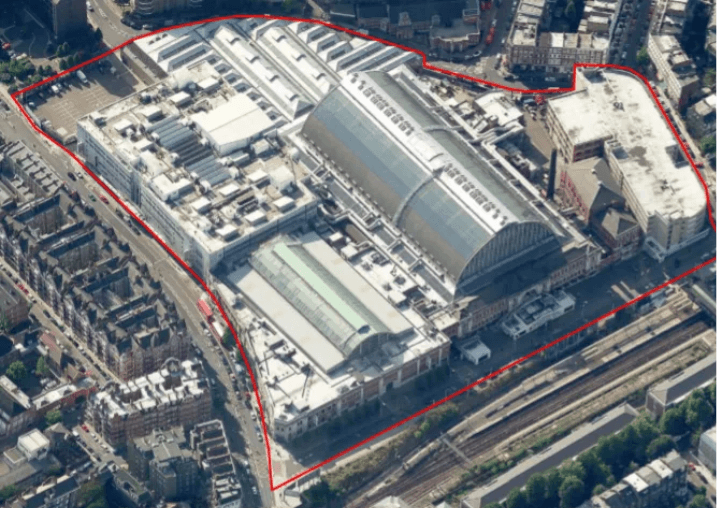
- Site Area: 14 Acres
- Technology: UAS, Laser Scanning, Point Cloud, Revit
- BIM Standards: BS1192 / BS8541
- Deliverables: Unified Point Cloud & BIM Model
Project Overview
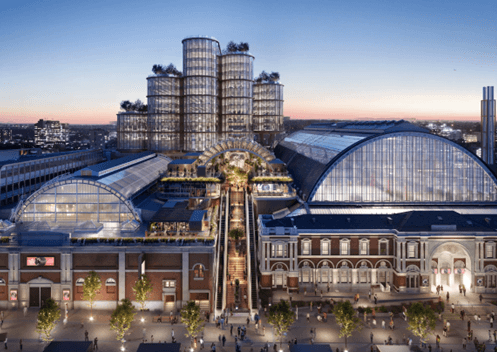
Olympia London, one of the world’s most iconic exhibition and events destinations, was undergoing a £1bn transformation to establish itself as a global hub for culture, entertainment, innovation, and creative enterprise.
This project showcases the advanced Scan to BIM capabilities our specialists bring to VectorQX, demonstrated by their prior leadership in delivering comprehensive digital solutions for large-scale operational campuses like Olympia London. Their work involved multi-disciplinary surveying, reality capture, and the development of high-definition BIM models to support design coordination and long-term facilities management.
The project established a reliable digital foundation for one of London’s most prestigious redevelopment programs, enabling informed decision-making across all phases of the asset lifecycle.
Client Challenge
Delivering a complete digital representation of a large-scale operational venue presented significant technical and logistical complexities. The site comprised interconnected historic structures, expansive roof systems, underground utilities, and continuously active event spaces requiring uninterrupted operations.
Key project challenges included:
- Capturing inaccessible roof structures safely and accurately
- Coordinating multi-disciplinary survey activities within a live public venue
- Working around event schedules and restricted access windows
- Managing UAS operations in areas affected by RF interference
- Integrating internal, external, and underground datasets into a unified model
- Delivering phased BIM outputs aligned with project development priorities.
Scope of Work
The engagement scope involved a fully coordinated reality capture and BIM modelling program that included:
- Topographical surveys
- Building and utilities surveys
- Terrestrial laser scanning
- UAS-based aerial surveys.
- 360-degree panoramic photography
- Point cloud processing and registration.
- BIM model development in Revit
- BIM consultancy and standards coordination
- Phased model delivery aligned with project milestones.
The Solution
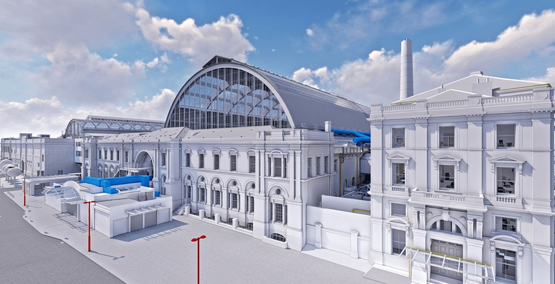
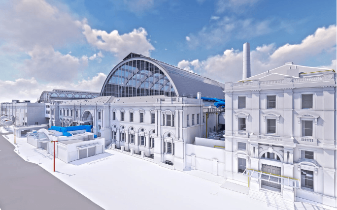
The project approach combined aerial, terrestrial, and underground data acquisition methodologies to generate a complete and highly accurate digital representation of the Olympia campus, reflecting the multidisciplinary expertise available within the VectorQX team.
Unmanned Aerial Systems (UAS) were deployed to safely capture complex roof geometries and inaccessible areas while maintaining operational safety within a busy urban environment. Detailed flight planning and real-time testing enabled stable data capture despite RF-sensitive conditions surrounding the venue.
The aerial datasets were integrated with terrestrial laser scanning, underground utilities mapping, total station observations, and 360-degree photography to create a unified, high-accuracy point cloud environment.
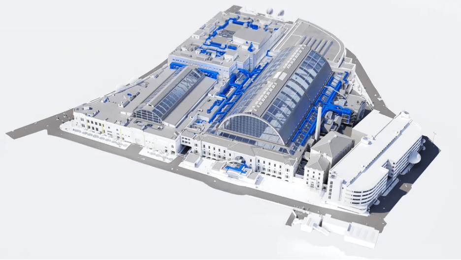
Using the consolidated point cloud dataset, a structured Revit BIM model was developed across six phased volumes aligned with the client’s design and construction priorities, reflecting the expertise available within the VectorQX team.
The engagement also involved BIM consultancy support for establishing modelling standards, naming conventions, and level-of-detail strategies in accordance with BS1192 and BS8541 requirements. This ensured consistent information management and seamless collaboration across stakeholders.
Throughout execution, survey and modelling activities were coordinated around ongoing exhibitions and public events, minimizing operational disruption while maintaining program efficiency.
Key Deliverables
- Unified federated point cloud environment
- High-definition Revit BIM model
- Phased BIM model delivery packages
- Topographical and utilities survey outputs.
- 360-degree visual documentation
- BIM Level 2 compliant information structure
- Long-term digital asset framework for facilities management
Project Benefits
- Comprehensive Digital Asset Creation
Complete capture of architectural, structural, and underground assets eliminated the need for repeated site visits and provided reliable asset intelligence for the redevelopment program. - Enhanced Safety and Survey Efficiency
The use of UAS and coordinated survey planning enabled safe access to complex roof structures while minimizing disruption to live venue operations. - Improved Design Coordination
Phased BIM delivery and BIM-compliant workflows streamlined collaboration between architects, consultants, engineers, and client teams. - Long-Term Facilities Management Readiness
The BIM model established a future-ready digital asset supporting lifecycle management, maintenance planning, and operational decision-making.
Project Outcome
The project demonstrates the capability of the VectorQX team members in contributing to high-fidelity Scan to BIM environments supporting large-scale redevelopment programs.
By combining advanced reality capture technologies, BIM consultancy expertise, and phased model delivery, the project enabled accurate planning, reduced program risks, minimized future re-survey requirements, and established a scalable digital asset for long-term operational management.
Technology Stack
- Autodesk Revit
- AutoCAD
- Laser Scanning Technology
- UAS / Drone Survey Systems
- Point Cloud Processing Software
- BIM Coordination Platforms
Need a scalable Scan to BIM partner for complex infrastructure projects?
Connect with VectorQX to explore scalable BIM delivery, reality capture expertise, and coordinated digital asset development capabilities.

")